الموقع
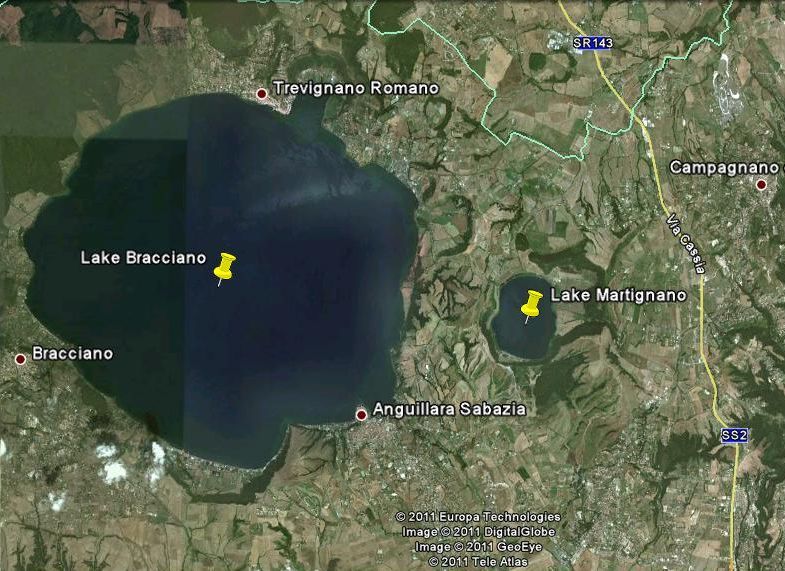
District of Lakes Sabatini
Aseries of volcanic eruptions that took place about a million and a half years ago up to 40,000 years ago in the region, implicated the materialization of the volcanic system, today known as Sabatino system. Once eruptions had stopped the craters were filled with water to form four lakes. Two of these (Martignano/Alsietinus and Bracciano/Sabatinus) still exist, the third (Baccanello), was drained in Roman times, while the fourth (Stracciacappe) was drained in the 18thcentury since it was reduced to just a marsh.The district is situated about 35–50 km NW of Rome and its terrain is hilly with an altitude varying from 150 to 600 metres. Because of the temperate climate the vocation of the territory is shifting from a non-intensive farming towards experiences of urbanization and tourism.
About lacustrine biota the following can be observed:
1. There exist considerable sections of riparian forest (poplar, alder and willow).
2. The area has rich and varied ichtyofauna (pikes, perches, whitefishes, eels, tenchs,carps, latterinos, etc.), that still provides a vital basis of the local economy.
3. There is abundant avifauna (ospreys, seagulls, cormorants, egrets, snipes, widgeons, lapwings and many migrating birds of wetlands).
4. While wild mammals are rare, nutrias, badgers, porcupines and hedgehogs can be sighted while others are essentially disturbed by the increased urbanization and tourism.
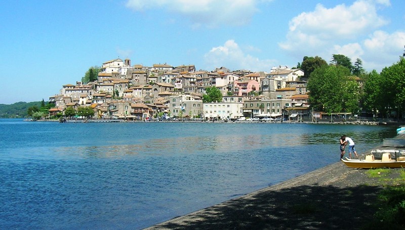
Three small towns are on the edge of the Lake (Anguillara Sabazia, Bracciano and Trevignano Romano) while a fourth NW of the Lake(Manziana), has the privilege of overlooking it from above.
In 1999 the Regional Natural Park of Bracciano-Martignano was established with the aim of bringing the territory under environmental protection.
Hydria Virtual Museum
Table of the principal parameters of Bracciano and Martignano lakes
| Lake Altitude (m a.s.l.) | Area (km2) | Volume (km3) | Max Depth (m) | Mean Depth (m) | Cathment Area (km2) | Outflow discharge (m3/s) | Renewal Time (years) | |
|---|---|---|---|---|---|---|---|---|
| Martignano | 207 | 2.4 | 0.13 | 60 | 43.0 | – | 0 | ~ oo |
| Bracciano | 164 | 57.2 | 5.05 | 165 | 88.6 | 146.7 | 1.17 | 137 |
Lake Martignano
Lake Martignano is a small lake, about 33 km from Rome NNW, close to Lake Bracciano. Its perimeter is 6 km (max length 2.015 km and max width 1.545 km), its surface area is of 2.44 km2, its current max depth 60 m and its surface elevation is 207 m a.s.l. The lake has several small tributaries, mostly seasonal, but has no a real outlet, only a seasonal gutter allows overflow spilled into the underlying Lake Bracciano. In ancient times the lake was called “lacus Alsietinus”.
The presence of a tunnel located 12 m above the current level of the lake has been puzzling the historians. The doubts stem from the fact that the tunnel led both to Lake Bracciano and to a branch that is connected to the drainage channel coming from the former Lake Stracciacappe. According to some it was an emissary during the 1stcentury (when the lake level was high), while others support it was a tributary from Lake Stracciacappe during its drainage.

Hydria Virtual Museum
The water level has changed over the centuries; according to some historical reconstructions the level dropped by more than 10 m in the 2nd century AD and increased again in the 17th century.
Currently, with the exception of very few houses and two farms, the lake is not surrounded by any town or village neither any constructed road. It is possible to reach the lake only by foot as car parking is rather far away and at a level of about 50 m above. Motorboats as well as bathing facilities on the shore are banned. These conditions keep the site rather uncontaminated. However mild touristic activities such as trekking, sailing, canoeing and swimming sports are encouraged and this has made the Lake a popular weekend attraction and especially for young visitors.

Hydria Virtual Museum
Lake Bracciano
The lake Bracciano (called “Lacus Sabatinus” in ancient times) occupies the principal crater of the Sabatino volcanic system: the intense volcanic activity created many small craters in the territory, and some of them are still recognizable around the Lake itself.
It is nearly circular, and is located in the northern Province of Rome. Its perimeter is of approximately 32 km and has a surface of 57 km2 (second in Lazio region and eighth in Italy). Its max depth is of 165 m and has a volume of over 5 billion m3; its catchment area has an extension of about 150 km2, and its surface elevation is 160 m a.s.l
The Lake Bracciano has been preserved until the Second World War, but afterwards, during the 60s and 70s it has suffered a progressive increase in discharges from coastal towns and farming. The lake is fed by the runoff of rainwater falling in the catchment area and by groundwater that spills into the water body of the Lake. It has only one natural emissary: the torrent Arrone, that drains to the Tyrrhenian coast north of Rome.
In the past the Lake Bracciano and particularly the port of Bracciano was one of the two seaplane bases of Rome. Furthermore, in the years 1938 – 1940, it served as a staging area to the British Imperial Airways flights from London to Bombay and other destinations of North Africa and Middle East. The service stopped in June 1940 when Italy declared war to Great Britain.

Hydria Virtual Museum
As Lake Bracciano serves as a drinking water reservoir for the city of Rome it has been under pollution control since 1986. In order to avoid contamination all sinks flowing towards the Lake were put under control; organic agriculture practices around the Lake have been adopted; and a centralized sewer system serving the bordering towns has been built. Furthermore, the use of motorboats is forbidden with the exceptions for few professional fishermen and the authorities. This has favoured trekking, sailing, canoeing and swimming. Today there exist many sailing clubs on its shores and several regattas are performedat local, national and international level. All these circumstances have transformed the site to an important tourist resort. The tourist activities have not a strong impact on the environment: many restaurants or taverns and small hotels or inns characterize the visitor’s receptivity. Probably the vicinity with Rome, and consequently the weekend holiday did not encourage the construction of large scale accommodation facilities, but only scattered houses around the lake, especially as second homes. In addition to tourism, fishery and rural activities are the most important economic enterprises developed on site.
In 1989, a prehistoric village of about 8000 years ago was discovered in Marmotta area (near the beginning of Arrone torrent). The village was located into the subbed of Lake at 360 m from the shore and 8 m below the water level. It can be considered the oldest settlement in the Neolithic Era of Western Europe. During the excavation, ceramics of different shapes, sizes and functions have been found (including dishes, tableware, small glasses, large containers for liquids and foodstuffs, tools for daily life and also two pirogues). The discovery of different kind of seeds (wheat, einkorn, barley, lentils, broad beans, flax, poppy) and of remains of sheep, goats, cattle and pigs show that the community was no longer nomadic and had developed agricultural practices already.
Nowadays, three small towns overlook the Lake at regular mutual distances, that is Bracciano Trevignano Romano and Anguillara Sabazia.

Hydria Virtual Museum

Hydria Virtual Museum
Hydria Virtual Museum