Waterworks
In the fourth year of the 98th Olympiad (385/4 BC), the Parians, Ionian Greeks from the island of Paros in Aegean Sea, at the invitation of the tyrant of Syracuse Dionysius the Elder, established in Hvar the city of Pharos, in the deepest bay of the northern side of the island. The idea of Dionysius, the founder of Issa, the first Greek colony in the Adriatic, was to provide a suitable base for further military and commercial expansion, totally dependent on the metropolis of Syracuse.
Pharos was a markedly agrarian colony. The cadastral division of the fertile Stari Grad Plain, or plain, is a monument in itself. Actually Hvar includes the largest fertile area between the Adriatic islands. This is probably one of the reasons why Hvar was chosen for settlement by the Parians, which together with the climate and the abundant springs made it ideal for agricultural development.

Hydria Virtual Museum
The organisers of the colonization divided land equally amongst the settlers -a few hundred families- in equal rectangular plots of fertile land (chora). For that purpose, they used simple instruments including groma (an instrument to lay out straight lines and right angles, comes grom the greek “γνόμων” which means ruler / indicator ) and kalamos (= reed or wodden rods to measure length, equal to ~ 3 m in todays units). With these instruments they divided the field into rectangular plots in equal size of 905 x 181 meters, in other words and according to their measures 5 x 1 stadi (16 hectares in today’s measures). There were 73 plots in the plain. They also carved boundary stones bearing the names of the parcel owners. The paths among the plots were separately measured and inscribed as the town property. The main place from which they took the measures is omphalos, (found today on the road connecting Stari Grad to Vrboska, very close to the beginning of the sport airport).

Hydria Virtual Museum

Hydria Virtual Museum
Hydria Virtual Museum

Hydria Virtual Museum
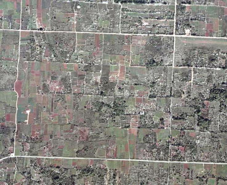
From omphalos, all chorae could be seen in the best way. Between those plots, there were roads leading to the town, and they can be seen even today as well as the dry-stone walls bordering the plots. These plots of land can even be seen on the satellite photograph, which is not the case in any other Greek settlement or colony in such an impressive way.

Hydria Virtual Museum
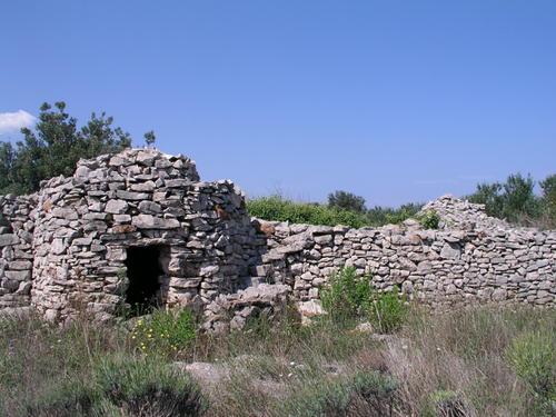
This clarity on the land is all due to the hands of the farm labourers who from the most ancient times have bounded their plots with the many dry stone walls, of various different dimensions. Some of them are just a common fence between two holdings, while others (on the whole those that were built on the basis of the Greek surveyors’ lines) are very broad, and have also been used as roads. Apart from that, there are also the scattered many country huts built in dry stone, known as trims. Some excavation evidence near Stari Grad suggests that part of the population lived on the plain itself.
_Ministry.jpg)

Hydria Virtual Museum

Hydria Virtual Museum
Hydria Virtual Museum

Hydria Virtual Museum

Hydria Virtual Museum
Though the land is fertile, the Mediterranean climate, with its moderate precipitation, is the cause of frequent water shortages, for which reason over the whole of the field there are a great many large or small cisterns for the collection and retention of rainwater, mostly built underground.

Hydria Virtual Museum

Hydria Virtual Museum
One of ancient wells was discovered in 2009 within the southern wall of the ancient Greek city – near the old road from Stari Grad to Hvar. This well is estimated to have been built in the 300s BC, probably for military purposes. During the roman period, a lot of cisterns were built in the Stari Grad plain, some of which are still in use. Water management in antiquity involved also the control of the stream Pharion.
The abundance of streams and springs in antiquity indicates a high level of subterranean waters. The crops of the plain were probably irrigated through the wells, the springs, as well as the rainwater collected in the cisterns. It is assumed that there was no need for irrigation from the river, or, stated otherwise – the channels were not used for irrigation but for drainage, instead!
In spite of the many turbulent events over the centuries, and the repeated divisions of the land inside the plain, the basic structure set by the Greek land division 2400 years ago remained almost untouched. The Greek chorae are very well preserved in the dry stone walls that mark the borderline of the plots. Although most of what we see today were created in the Middle Ages, they still lie on the directions laid down in antiquity. The many subsequent redivisions of the land and the small amount of building that took place in the plain have always, from antiquity until the present day, been done in the same way, i.e., with the traditional dry stone wall technique.
In today’s research, the problem of locating the ancient rivers appears. In the central island of Hvar there are few occasional torrents but not a main one. Which one of these watercourses was mentioned in the works of the ancient Greek writer Ephorus, we can only speculate. It is assumed that a river was flowing into the sea around the Stari Grad of today. However, today the watercourses are only occasionally present in the vicinity of the old town fields (Lucijica and Krušvica). These cannot be called rivers but rather seasonal streams active only after a prolonged rainy season.