Waterworks
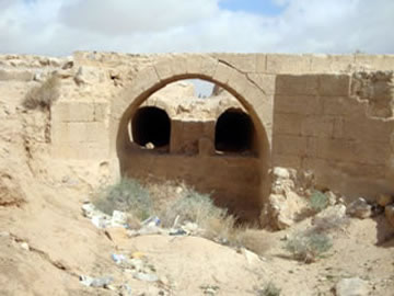
People of the Roman and Byzantine eras often transported water over considerable distances to cities, towns, villages and buildings. The efforts conducted by the Department of Antiquities (DAJ) team around Qatranehrevealed the presence of aqueducts which link the el-Hasa wadi with the nearby ones and the main pool.
The increasing demand for water to be used for domestic and other purposes was the reason for constructing this water system. The channel, which is partly preserved, reaches the site of a medium size settling tank, and is then directed to the pool.

Hydria Virtual Museum
Only few remains of the channels, stone ashlars and foundations were discovered in site. The bases of the well-cut ashlars consist of field stones with gray lime, while well-cut sandstone ashlars possibly built over an arch system carried the water from the southern part of the wadi to the settling tank.
The recovered pools and cisterns are one of the important discoveries east of the Jordan River and are associated with the local settlement which later became the site of Qatraneh. They were also used during the Roman, Byzantine and Islamic periods. It is located on the desert highway that links Amman to Aqaba (distance between the two towns 335 km). Qatraneh is 90 km South of Amman with an elevation of 790 m above sea level.
The castle is 22.20 meters long and 17.35 meters wide while its average height is 10.0-10.5 meters higher than the wadi. The main gate (185 cm x 140 cm with a thickness of 35 cm) is in the middle of the eastern wall of the castle.

Hydria Virtual Museum
To the south of the site is the Hanifa wadi which flows from a southeasterly direction. Another wadi by the name of Hafayer flows into Hanifa wadi. Both these were the sources and basis for the construction of the water harvesting system that provided the site with water.
Hydria Virtual Museum
The water system that provided the inhabitants with clean water for drinking and irrigation was therefore comprised of an earth dam, two water canals , a settling tank and a main storing pool connected to a well , located inside the castle for easy access to water. The main pool which is 26 meters away from the castle has a surface of 70 m x 70 m with a depth of 5.2 m. The earth dam is about 75 meters away from the castle site. The settling tank, east of the main pond is 38 m by 6.6 m with a depth of 2.4 m. A dual canal system each one at 105 cm wide and separated by a 90 cm distance, transported the water from the earth dam to the precipitation pond.

Hydria Virtual Museum

Hydria Virtual Museum
Hydria Virtual Museum

Hydria Virtual Museum

Hydria Virtual Museum

Hydria Virtual Museum

Hydria Virtual Museum
The total scheme of the water works at the Qatraneh site is depicted in a diagram:

Hydria Virtual Museum
The importance of the Qatraneh Site
During its operation, the Qatraneh site and castle, used to serve the following functions:
1. It was a strategic point during the Ottoman Empire, where travelers stopped for water, food and commercial interaction.
2. It served as a security checkpoint to protect pilgrims going to Mecca for the Hajj.
3. It was a point of supply for food and water for the Ottoman military troops, as well as for military equipment.
4. In recent times the castle has been linked with the Hejaz Railway station.
5. The water harvesting system of the site provided a source of water to the inhabitants of this dry area, especially during the summer.